Click on the map to view full size

Download Map PDF (1.6MB)

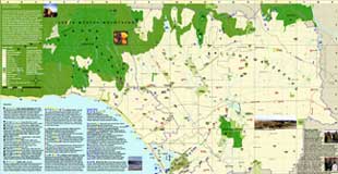
The Ballona Watershed Green Map displays ecological and cultural resources found throughout the Ballona Watershed, such as important waterways, wildlife migration routes, wetlands, public lands, alternative transportation corridors, environmental organizations and green businesses.

WHAT IS A WATERSHED?
and why make a watershed map?

A watershed is an area of land that drains all rain that falls within it to a common point. This map identifies environmental features and resources in the Ballona Watershed, which is part of the larger Santa Monica Bay watershed. The Ballona Watershed drains through Ballona Creek to Santa Monica Bay.

A watershed is an important way to organize how we think about natural relationships between water, earth, and people. Watersheds provide habitat for plants and animals and provide important environmental benefits such as water filtration and storage. The hydrologic cycle (precipitation, percolation and evaporation) intersects with and shapes earth's topography, contributing to unique combinations of plant and animal species. Humans are also part of watersheds, relying on their water and unique environments, yet, by channeling streams and paving over the earth humans have drastically altered the original percolation and filtration zones of the watershed. It is our hope that the reader will contemplate these changes, and also dream of how we might restore some of the watershed while continuing to enjoy living an urban life in Southern California.

The Ballona Watershed Green Map shows the entire watershed of La Ballona Creek, including the communities of Santa Monica, Culver City, Beverly Hills, Inglewood, West Hollywood, Venice, West Los Angeles, and Los Angeles and the natural features that run throughout the watershed. These features include:

> Watershed definition and boundaries
  > Existing as well as former creeks and streams
  > water sources inventory (where the local water comes from)
  > fresh water sources such as reservoirs and lakes
  > storm water pollution sources (which affect water quality in the watershed and Santa Monica Bay)
  > bird migration corridors and species
  > native plant, butterfly and animal information
  > endangered species
  > state parks
  > current greening and habitat restoration projects and opportunity sites
  > environmental schools (schools that have agreed to unpave a large percentage of asphalt and plant trees)

back top of page